
NATIONAL PARK SERVICE TRAIL RATING SYSTEM
- Easy – uneven ground, but fairly level
- Moderate – some steep grades, some level stretches
- Strenuous – steep grades, many steady climbs
Hunt Trail to The Owl (3,670 ft.)
Team Red, Team White, and Team Blue
NPS rating: Strenuous
This mountain is the first summit in the long, high range that runs west and north from Katahdin around The Klondike Stream and is especially steep.
From Katahdin Stream Campground, follow Hunt Trail for 1.1 mi. (approx. 45 mins) to a junction at 1500 feet. Here, The Owl Trail leads left at a point just before the crossing of Katahdin Stream. The trail then follows north the bank of a tributary before turning sharply right (southeast) and crossing the tributary at 1.6 miles (last source of water). The trail climbs gradually through dense spruce and fir and follows the western spur toward the summit. At 2.9 miles the trail rises steeply through a ravine and then across the upper part of The Owl’s prominent cliffs. At 3.4 miles the trail reaches the first outlook. After a more gradual climb, it reaches the summit at 3.5 miles. Views in all directions are outstanding, especially those into the Klondike and Witherle Ravine.
3.5 miles: 2 hours and 40 minutes to summit

Rainbow Loop Trail (1,640 ft.)
Team Gold
NPS rating: Moderate to Strenuous
Rainbow Loop Trail is the combination of (3) different trails (Blue Trail, Rainbow Loop Trail, and Horserace Pond Trail) ranging from MODERATE to STRENUOUS difficulty ratings. This trail starts at nearly approximately 600′ above sea-level before rising up and down vertical ascents in excess of 1600′. This beautiful trail system is located off of the Golden Road just outside of Baxter State Park and is managed by The Nature Conservancy’s northern Maine field office.
From the trailhead, follow the Blue Trail (marked with blue blazes) 0.6 miles where it will intersect with Horserace Pond Trail. Turn left and continue on Blue Trail for another mile. During this stretch, you will quickly climb to approximately 1,340′ before reaching the next trail intersection at 1.6 mile mark with Rainbow Loop Trail. Take a right onto Rainbow Loop Trail (marked with orange blazes) and climb down approximately 100′ before beginning your next ascent to 1,640′. At this elevation, we find the second scenic overlook, marked with a star below on the map and approximately 3.0 miles into the overall trek. This is where the Circle Testimonies will take place. Once complete, continue on to Horserace Pond at the 3.6 mile mark. Then use Horeserace Pond Trail (marked with yellow blazes) to trek to the 5.6 mile mark at the intersection of Horserace Pond Trail and Blue Trail. Take a left onto Blue Trail (marked with blue blazes) and return to the trailhead to finish the 6.2-mile journey.
6.2 miles: 3 hours, 50 minutes total hiking time

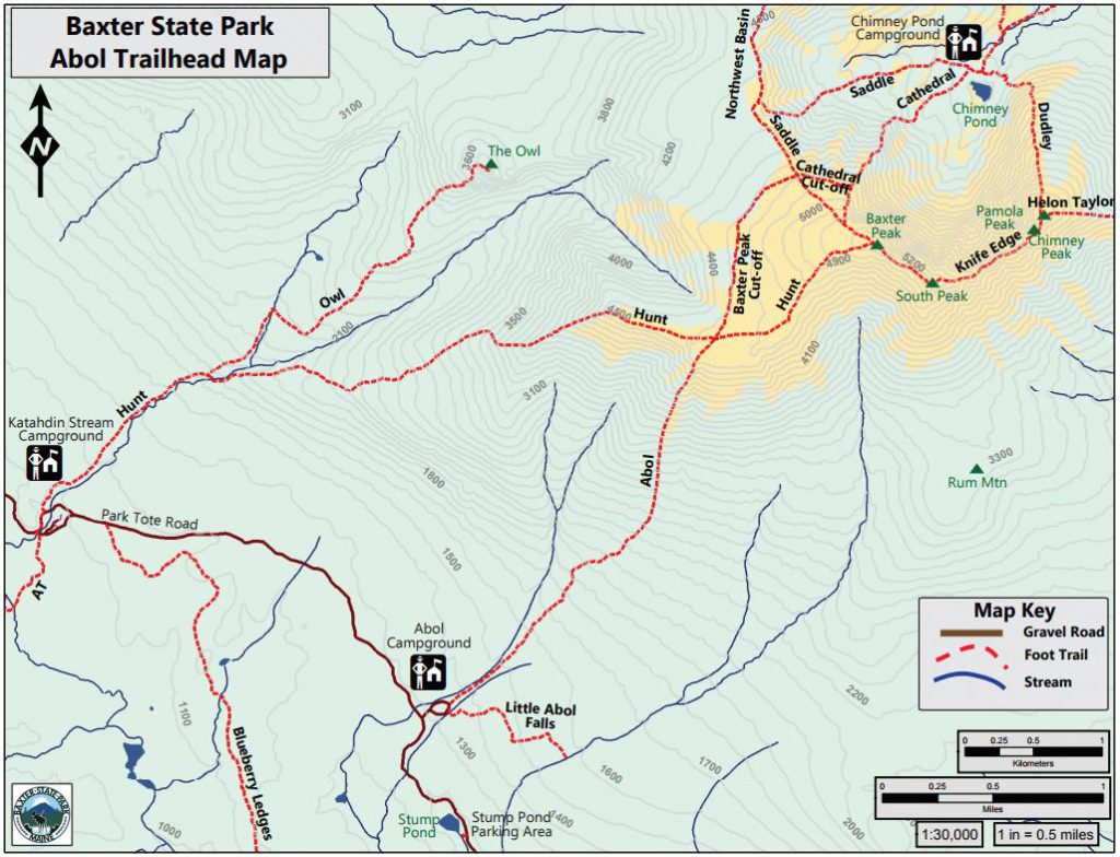
Abol Trail – Mount Katahdin (5,268 ft.)
(Alternate)
NPS rating: Strenuous
Abol Trail is believed to be the oldest route up Katahdin, and evidence exists that the first recorded ascent took place near this trail. It follows a great slide up the southwestern side of the mountain. (Note: This route is steep and entails hiking over a large amount of loose rock and gravel in the slide. Please climb and descend with great care.)
The trail leaves Park Tote Road at Abol Campground. The trail passes through the campground and, at 0.2 miles, enters an old tote road to reach the southern bank of a tributary of Abol Stream. Abol Trail continues along the stream for 0.6 miles before the trail bears sharply right (northeast) away from the brook. The trail reaches a gravel wash of old Abol Slide (1.3 miles) and climbs to reach a second slide at 1.9 miles. Beyond this point, the route is steeper and is almost entirely bare rock and loose gravel. Large boulders and increasing steepness mark the latter part of this climb. Upon reaching the tableland, the trail leads 0.1 miles to Thoreau Springs (unreliable water source) and the junction with Hunt Trail at 3.2 miles. Turn right on Hunt Trail and continue northeast up gentler slopes to the summit at Baxter Peak, which is reached in an additional 1.0 miles.
4.2 miles: 4 hours and 5 minutes to summit
River Pond Trail (0 ft.)
NPS rating: Easy
The River Pond Nature Trail is a small network of trails wandering through mixed hardwood forests and actively managed timber lands. The terrain is mostly flat with a narrow winding trail suitable for most hikers. Moose Point is a highlight of the trail, with wide views of River Pond and Mt. Katahdin looming across the lake. This is an excellent location for the circle ceremony. The area is best seen on the 4-mile loop that begins from the primary trailhead and connects the Tenderfoot Trail, Timber Cruisers Trail, and the Foresters Trail.
Tenderfoot Trail: The trail starts at the primary trailhead and weaves back and forth next to River Pond for about 0.75 miles before meeting the Bluebird Trail and Timber Cruiser Trail. Keep an eye out for moose from the couple of viewpoints overlooking River Pond.
Timber Cruisers Trail: This trail makes a 1.3-mile arc on the northwest side of the network, connecting with the Tenderfoot Trail by River Pond, the Foresters Trail by the Penobscot. Moose Point is the highlight for the whole area with wide views of River Pond and Mt. Katahdin. Large, halfway submerged rocks on the point make a great lunch spot.
Foresters Trail: This 1.7-mile trail meanders from the Timber Cruisers Trail back to the primary trailhead. Take note of changes in forest cover and species here as the trail goes back and forth between a conservation easement and actively managed timber land.
From Millinocket, follow the Baxter Park Road toward Baxter State Park. Turn left on Pockwockamus Road (immediately before the painted Pockwockamus Rock). After less than a mile, turn right on the Golden Road. Less than a mile later, the River Pond Nature Trail is down a short, marked access road on the left. The primary trailhead is about a quarter mile from the Golden Road and accessible to most vehicles. A second trailhead can be reached with high-centered vehicles by following the access road for another mile.
Please note: the Golden Road is a private logging road; all visitors must yield to log trucks.

DoubleTop Trail (2,454 ft.)
(Alternate)
NPS rating: Strenuous
Doubletop offers some of the most amazing views in the Katahdin region. These views are well earned on this 7.4 mile route with 2311’ of elevation gain. To access the trailhead, cross the bridge over Nesowadnehunk Stream. The first quarter mile is relatively flat while the trail runs parallel with the stream. Around 1.8 miles the trail crosses Doubletop Stream, and then climbs steeply over rocks and roots, at times requiring the use of rocks and roots for hand holds. Around 2.4 miles the trail levels out some and winds through a nice forest before becoming steep for the remainder of the climb. At 3.5 the first summit, North Peak (Elev 3489’) is reached. From there a .2 mile scramble through some scrub brush gains South Peak (Elev 3455’). South Peak offers spectacular views and space to hold the circle ceremony, but if weather persists, North Peak would be a better choice.
This is an up and back route, so return along the same path.
